Maps Page on Ethiopia
Outline
- Physical Environment
- First map name
- Second map name
- Third map name
- Weather & Climate
- First map name
- Second map name
- Third map name
- Human Environment
- First map name
- Second map name
- Third map name
- Road maps
- First map name
- Second map name
- Third map name
- City Maps
- First map name
- Second map name
- Third map name
- Urban Transportation Maps
- First map name
- Second map name
- Third map name
- Tourist Maps
- First map name
- Second map name
- Third map name
1 Physical
Environment
https://www.freeworldmaps.net/africa/ethiopia/map.html
The map is meant to show a general idea of where Ethiopia
is located. Ethiopia is surrounded by the countries of Sudan, South Sudan,
Kenya, Somalia, Somaliland, Djibouti, and Eritrea in sub-Saharan Africa. It is
the 10th largest country in Africa with a population of around 110
million. This region is typically considered a hot spot of political activity
and considered a less traveled destination when it comes to tourism.
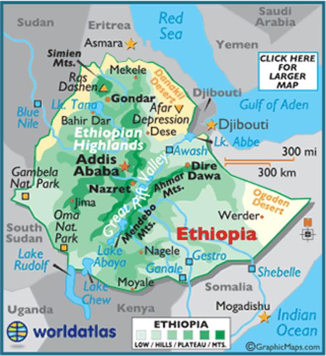
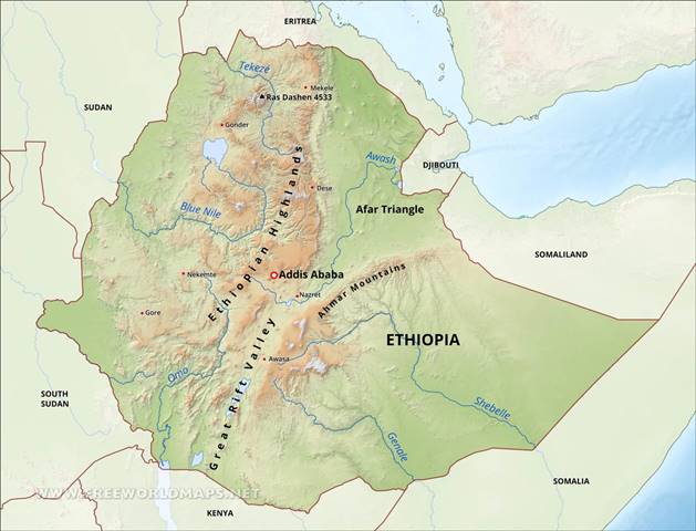
https://www.worldatlas.com/webimage/countrys/africa/ethiopia/etland.htm
A map that shows some of the physical characteristics of the country can be
seen above. Ethiopia varies from highlands to low desert. The map also shows
one of the reasons I chose this destination and that is the Great Rift Valley. You can also see why this region is considered
the horn of Africa by the shape of its border. It also shows some of the
mountain ranges and lakes.
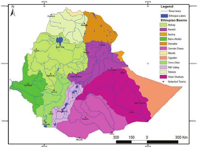
https://www.researchgate.net/figure/River-basin-map-of-Ethiopia_fig5_260144344
I chose this map as a physical map as it shows some of the basins and water
sources. This could probably go under the next category, but I felt this map
gives the reader an idea on the physical topography of the region which is
often considered to be complex.
2 Weather &
Climate
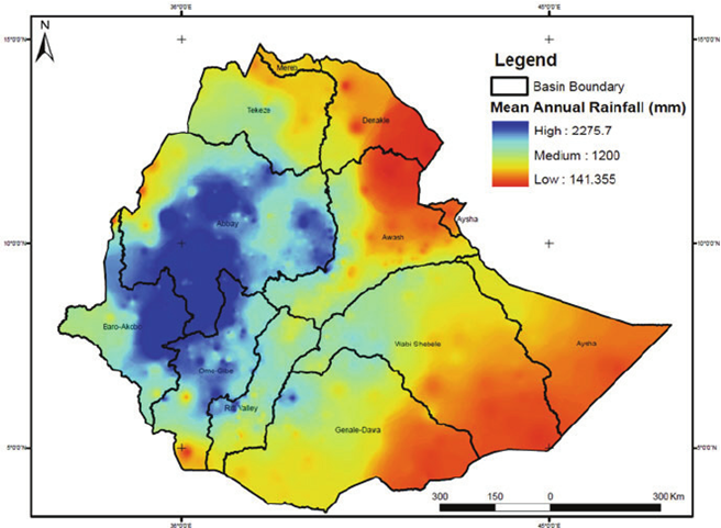
Because of the complex topography and heavy rainfall this
annual rainfall map can show you how much water is received in each labeled
basin. Rainy months are considered June-August and often during this period
flooding is common as the water systems capacity become exacerbated.
https://www.mdpi.com/2073-4441/10/11/1560
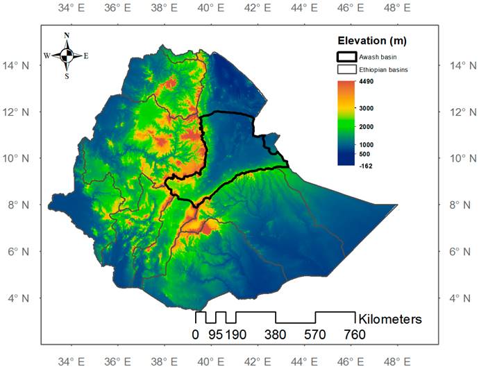
Elevation is important aspect to take into consideration for climate as
temperatures may vary widely from more elevated areas to the lower. A large
portion of the population is located along the Ethiopian highlands and the
Great Rift Valley. A 4600-meter change in elevation in 500 miles seems like a
drastic change and may be a good explanation on why the water systems become unable
to handle the water flow during rainy season. The Awash basin which is highlighted here is
important because the largest river runs into this space. During dry season it
is less than 5 feet deep but during the rainy season it can get to 60 feet
deep!
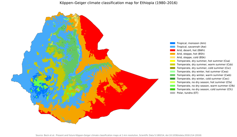
https://commons.wikimedia.org/wiki/File:Koppen-Geiger_Map_ETH_present.svg
To sum up the climate, I figured a map that showed the climate type was a
reasonable choice. You can corelate that the arid desert areas are not
receiving as much water as well as that the tropical areas being where most of
the population resides and where most of the rainfall occurs. It highlights
greatly the complex topography that I’ve been reading about. The land along the
mountain ranges essentially is the bearer of all that rain. I did not realize
that Ethiopia had such a tropical environment.
3 Human Environment
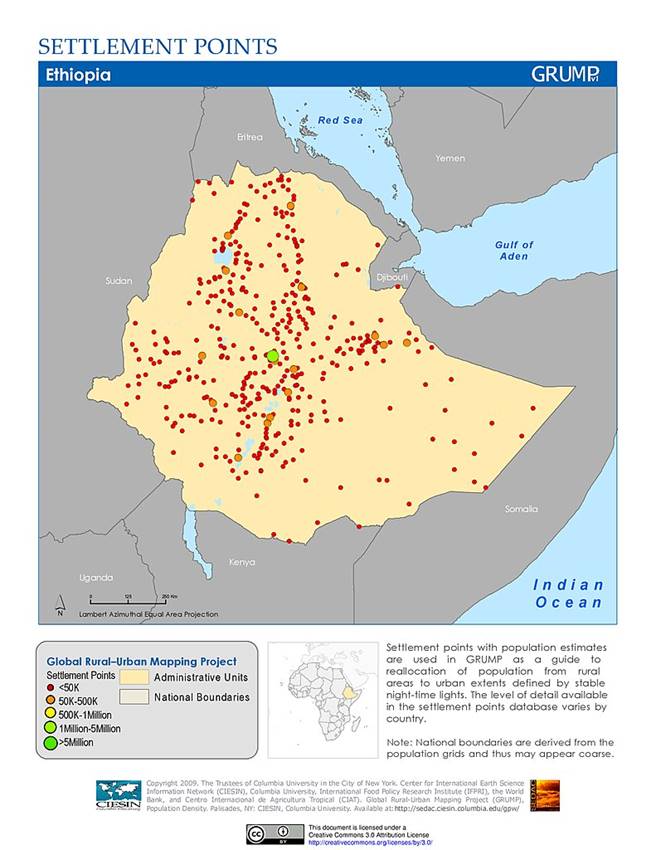
https://sedac.ciesin.columbia.edu/maps/gallery/search/5?facets=region:asia&facets=region:africa
I have mentioned already, and you can see here that most of
the population is grouped into the Western region. With plentiful water season
this could have had an impact on why people settled in this region. You can also see a disparity in population
size of settlements. There are many smaller villages of less than 50,000 people
while there’s several 50-500,000 with the primary settlement and capital of Ethiopia
in Addis Ababa with a population over 5 million people.
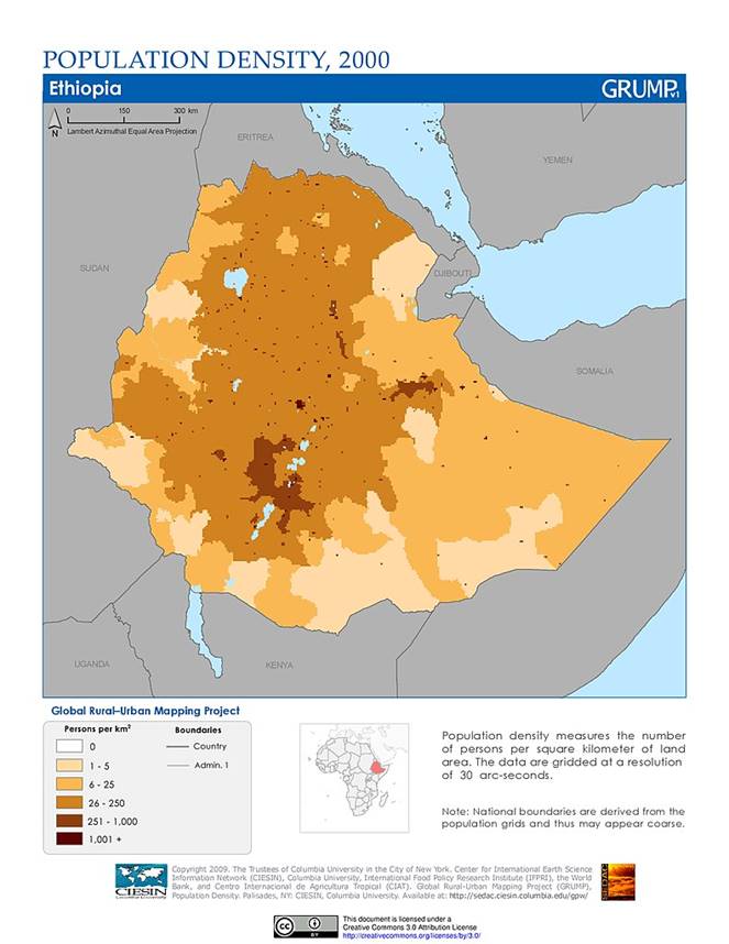
https://sedac.ciesin.columbia.edu/data/set/grump-v1-population-density/maps/3
This follow up map offers more depth to where people are in terms of density
by person per square km. Ethiopians measure using metrics. Again, you can
correlate natural characteristics to population location. Nobody is living in
the desert which could mean fewer resources such as water as well as its
location to Somalia which is often considered the pirate capital of the world. To compare to America, we have 90 people per
square mi. This is just over the average of Ethiopia, but America is many times
bigger as far as land mass goes 9X to be exact.
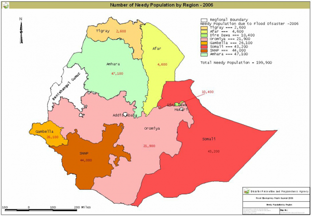
https://reliefweb.int/map/ethiopia/ethiopia-number-needy-population-region-2006
I had a more difficult time finding a map showing economic factors and this
map of the number of needy people by region was the best that I could conjure
up. I feel it does show appropriate data that is consistent on how we know
populations to move and settle. Again, the desert region shows the most need
for economic help. I find this due to likely low employment options, safety
factors and resources. I do find the SNNP (Great Rift Valley) region as
interesting as it needs more help as this is worse than Somali region. The
economy consist of subsistence agriculture, coffee, khat (tobacco like drug), horticulture,
mining and tourism.
4 Road Maps
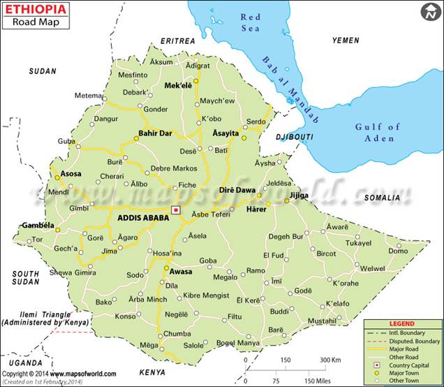
https://www.mapsofworld.com/ethiopia/road-map.html
This map shows the basic transportation system as far as
roads are concerned. It should help in identifying travel between places. It
highlights major cities from smaller towns as well as gives a good sense of
distances. A common theme is major roads only appear to be in the heavier
population areas as supposed to the areas we have discussed as being less
populated. This can help identify how easily one could commute as well as a
sign that certain areas such as the “horn” on the Eastern side where it may not
be as easily traveled with no major roads as more difficult.
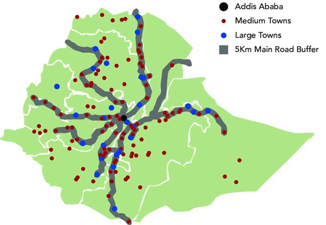
https://www.researchgate.net/figure/Map-of-Ethiopia-Depicting-the-Proximity-of-Medium-and-Large-Sized-Towns-to-Main-Asphalt_fig3_328861250
This map is similar as it shows a lot of the same data but also
shows a buffer. I presume that roads are not as cut and dry as we may find in
the West so it should be seen as a good reminder that traveling off the beaten
path may not be as easy or clear as what you see on a map. It is no surprise that
all activity snakes its way out of the capital city of Addis Ababa. Another thing
to note is the river system that is not labeled but present on the map.
https://www.pinterest.com/pin/476818679297107439/
I cannot believe that there weren’t many road maps that
were simple and easy to view. This seems to come out of an atlas as the date is
unknown. From the original you can see the major road systems complete with
everything you expect to find on an atlas road map. You can also see by the
green highlighted zones the different political areas or tribes/communities. In
the US I suppose we call them states but here they would be called providences
and there are 12 of them.
5 City Maps
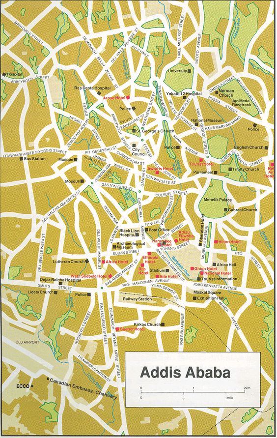
https://www.pinterest.com/pin/175007135492818581/
Being that the Capital is Addis Ababa I thought it would be
important to include the city map that shows street names as well as halls,
important buildings such as hospitals, police stations and churches. There are
no real straight streets which is important to consider as this is probably a
very busy area. Maps were one of the
harder portions of this assignment as many areas have experienced more modern
city planning and development as of late. Either way it may come in handy when
it comes to just exploring this city from the get-go.
https://vdocuments.mx/dire-dawa-city-tourist-map.html
This second map is a map of another large city that is
named Dire Dawa. This was also another map that was hard to locate. Although it
doesn’t show street names it does show a legend that can point you to hotels,
food, churches, hospitals, transportation hubs, phones and shopping areas. Even
with a minimalized map as this I think if I were to find myself here, I would
be able to locate these places via this map.
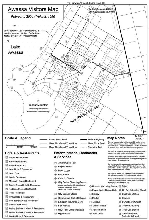
https://en.wikipedia.org/wiki/File:Awassa_Town_Map.jpg
The last map was meant to be a map of Mekelle in the Northern part of Ethiopia but was unable to locate a reasonable map to use. This map of Awassa was a second choice but this does show much of the important locations such as gas stations, entertainment, post offices, hotels, churches and food. This map was not intended for commercial use. It also differentiates paved roads from minor to major which seems to be an important aspect to consider when traveling. If I learned anything from A long way down, it was that traveling is not easy in Africa.
6 Urban
Transportation
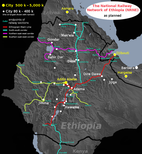
https://www.wikiwand.com/en/Rail_transport_in_Ethiopia
This first map takes into consideration the most popular
routes of travel and most used, being the railways. As you can see you have a
main line (red) which has sprouting corridors to other populated areas. One to
the SE/SW(yellow), one covering N/S (turquoise) and another covering E/W (purple).
If I were to use this system, I would feel confident knowing where I’m going
and the limitations of each route. I also notice a southern route being built
connecting travel from Kenya to the south or to Djibouti in the East. This map also shows a population estimate to
help you identify larger areas. Again, you can see not much exist in that horn
to the East.
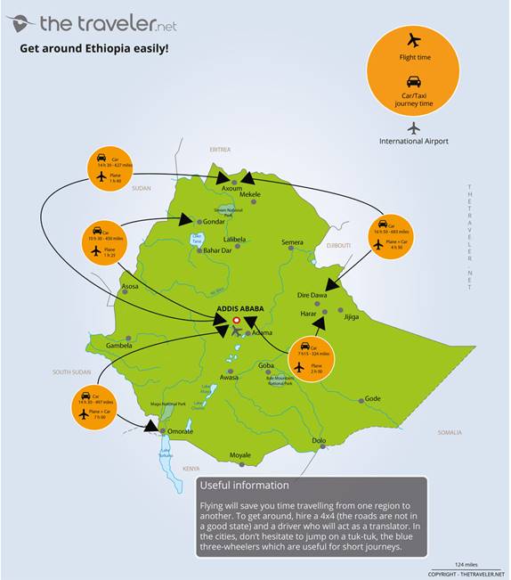
https://www.thetraveler.net/images/map/ethiopia/map-ethiopia-distances-1000.jpg
The second map gives the viewer a good depiction of travel
via plane and or vehicle. It gives time estimates which would be extremely
helpful in understanding the landscape. It states that the roads are typically
not in good shape so that would be important to know as well as the likeliness
of needing a translator if venturing off road.
It also mentions three wheelers that are common to rent for short
journeys. You can also see again that the capital city is the hub and almost everything
cycles through it.
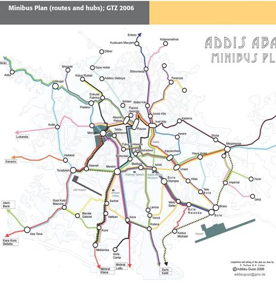
https://bitsofaddis.tumblr.com/post/92535837344/it-took-me-a-while-to-find-a-map-of-the-minibus
To include all modes of transportation I was happy to find
the minibus map plan for Addis Ababa. I will need to research more into this,
but the routes are color coded but do not mention time frames etc. It also
shows the airport as well as destination routes to other villages if leaving
from Addis. Just as the topography was complicated so does transportation.
Having examined all options would be important in determining the best ways to
move about the country and or cities.
7 Tourist Sites
https://favpng.com/png_view/motorcycle-ambulance-ethiopia-tourist-attraction-ethiopia-tourism-map-accommodation-png/F8ngy80R
For the tourist section, I started with a simple map that highlights
the main tourist traps. It appears that this includes mostly national parks
from the looks of this map but that is not all there is, so I had to look for
different maps to get more specific examples of tourist ideas. From this map it
can help you identify nearby towns or cities and which park and where that park
is located. Other than that, it is not as detailed as other maps but may be
helpful in the planning of excursions out to explore the country. It also helps
gain an understanding of your location.
http://travelsfinders.com/ethiopia-map-tourist-attractions.html
I enjoyed this map although it is busy. It shows some
visuals that are less boring than the first map. From this I can’t clearly see
where the parks are, but I see the visual aspect that clearly shows more water
activity than you would think judging from the landscape. I had talked about
water being abundant during rainy seasons but judging by this picture it seems to
be an important part of tourism here too.
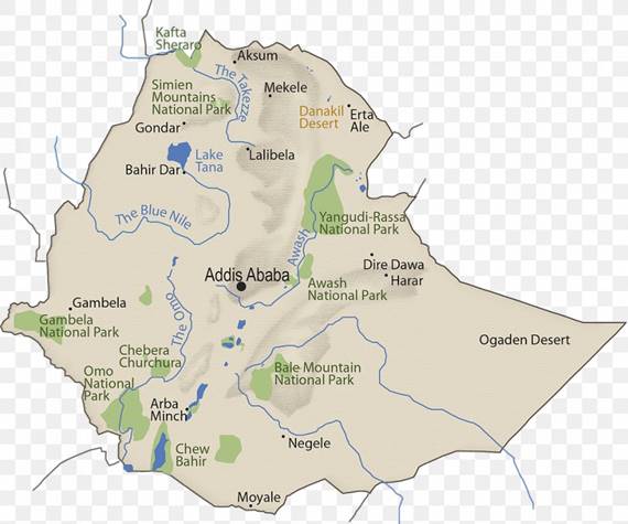
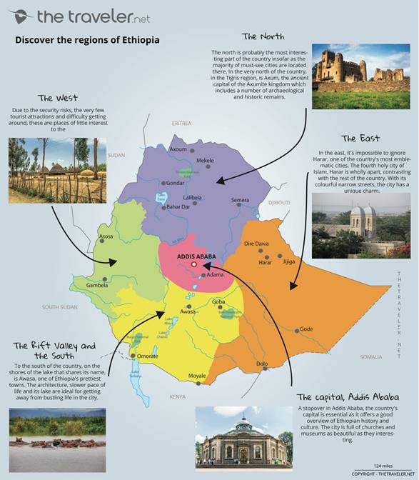
https://www.thetraveler.net/images/map/ethiopia/map-ethiopia-regions-1000.jpg
This last map is from the best source I found while researching
for this assignment. It’s easy to read and simple. It breaks the country into
regions, highlighting the important parts of each. From this map I can conclude
that traveling west may be difficult due to safety concerns. The North is
considered a must see due to historical archeology and importance to the
history. I was surprised to find the East as offering much but according to
this map it may be worth visiting the city of Harar. And of course, you cannot
forget about the most intriguing part of the country for me in the Great Rift
Valley in the South with lakes and architecture abound. This somewhat
contradicts info taken from previous maps. Perhaps I’ll take a second look into
the feasibility and safety of traveling here.
Submitted
by Nate Wallace on 3/6/2020