Street View Page on
Ethiopia
Outline
- Street View screen captures
- First Street View of
Blue Nile River Falls
- Second Street View of
Aksum, Ethiopia @ Axum Tsion St. Mary
- Third Street View of
Maryam Korkor (Rock-hewn Churches of Tigray)
- Links to Street View panoramas
- Link to Blue Nile River
Falls panorama
- Link to Aksum, Ethiopia
panorama
- Link to Rock-hewn
church of Tigray panorama
- Map Channels Street View Animation
- Route from Bahir Dar,
Ethiopia to Gondar, Ethiopia
- Route from Hawassa
Tabor Mountain Park, Ethiopia to Washington square on Gabon St, Addis
Ababa, Ethiopia
- Route from Danakil
Desert, Ethiopia to Martyr’s Memorial Monument, Mekele, Ethiopia
- Moore's Where to Invade Next
- The value of travel
1 Street View
Screen Captures
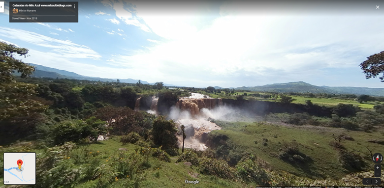
Blue Nile River Falls is an important resource to the people of Ethiopia. Its name comes from Amharic word Tis Abay, which means “great smoke”. It has proven to be one of the top tourist attractions in Ethiopia.
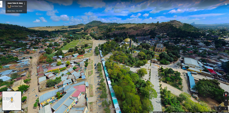
This is what appears to a street view provided by a drone at the intersection of the focal center of town in in the region of Tigray (northern Ethiopia) named Aksum or Axum. This was once a historical capital and now is a destination spot for tourist as it contains many historical archaeological sites.
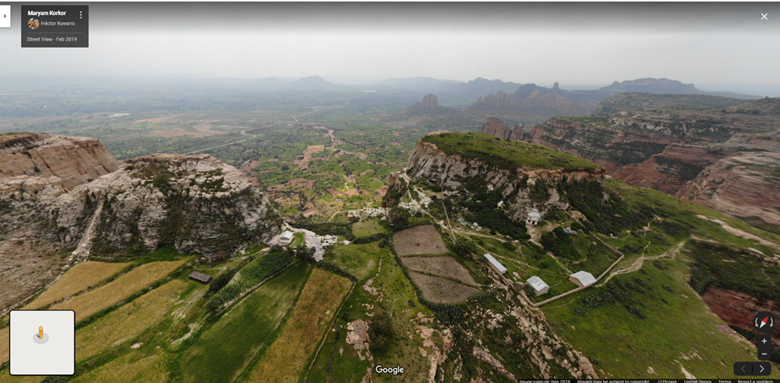
Maryam Korkor is a church carved out of the cliff in this street view picture from a drone. It is a network of tunnels and pathways that connect to 2 churches. Even to this day has yet to be fully excavated. It is a substantial piece to Ethiopia’s history and is often considered a do not miss when it comes to tourist but requires more effort to reach as it require a 45-minute walk to reach.
2 Links to Street
View Panoramas
Insert three links with descriptions to Street View Panoramas here. In contrast to above, these are "live links" so you'll be able to spin the image once they appear.
Example-1: Blue Nile River Falls
Blue Nile River Falls from the street view panorama taken by a group of travelers that you will see behind the falls. It helps put into perspective nature and man.
Example-2: Axum Tsion St. Mary, Aksum Ethiopia
Drone footage above Aksum, Ethiopia. You can see many of the tourist attractions within this picture. If you look toward the sky you will see the panorama appropriately labeled.
Example-3: Maryam Korkor (Rock-hewn Churches of Tigray)
This panorama offers a beautiful view of the Rock-hewn churches of Tigray. You may have to zoom in to see some aspects but I thought it was a very beautiful and important way to grasp the importance of a place such as this when it comes to the people of Ethiopia and their relationship with religion.
3 Map Channels
Street View Player
Route -1: (My
first Animation)
This animation will take you north on Halie Silase Rd in Bahir Dar, Ethiopia. It moves north along the Lake Tana to the east. Eventually you cross the Blue Nile River into the main highway through Abay, Ethiopia. And continue north through what I would consider suburbs up and around a few smaller villages and ultimately to Gondar, Ethiopia. Given the sites to view between the two I could see this small trip being a typical route between the two.
Route-2: (My second Animation)
In my second animation you will go from Hawassa (Awasa), Ethiopia-Mt. Park right outside of Lake Awasa through the city streets and ultimately onto Addis-Adama Expressway that will take you to a central point of Addis Ababa called Washington square.
Route-3: (My third Animation)
In my last animation you will be
taken from the Danakil Depression which is considered one of the lowest places
on earth as well as being labeled “hell on earth”. There is not a lot of people
in this region of Ethiopia. For the most part the scenery consist of mountains,
earth and desert until you reach Mekele and the monument which are meant to memorialize
past martyred freedom fighters and patriots.
4 Moore's Where
to Invade Next
The only thing that I think can be validated
is the way Michael More puts out the information. Sometimes when it comes to
things that are hard for people to see as truth, I feel there’s an attempt by
those who portray the “conspiracy”, dumb it down making it less believable.
Especially in the way it tries to point fingers at America. Mockumentary is
about as far as I’ll take it. What the documentary helps us understand about
visiting and traveling to other countries is that perhaps perception isn’t
always as it seems. Understanding the histories of other places can make you
more appreciative of the differences in way of life and even help one
understand the differences between another. Especially from an American perspective
given the role they have played in the world the last few hundreds of years. I
think overall, travel allows one to view things from another perspective and
thus helping that person understand themselves better. Perhaps even providing a
new appreciation for humanity.
Submitted
by Nate. Won 4/10/2020.